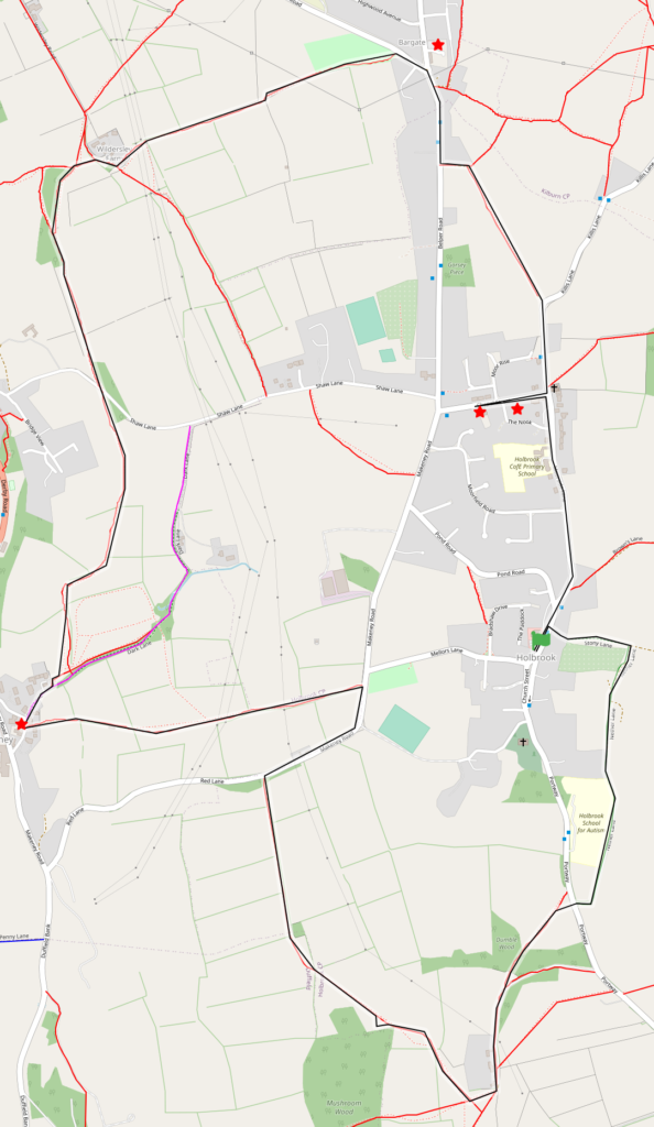
5 mile walk over undulating countryside around Holbrook, passing near 5 pubs.
Start point: Spotted Cow/Calf (free or on road if full)
Distance: 5 miles
Time: 2.5 hours
Stiles: yes
Livestock: Possible
Accessibility: For some. Squeeze and gate stiles and some steep sections, so walking boots/ wellies recommended.
Bus: Route 71. King St Stop A.
Route
Huge thanks to Holbrook Community Society and the Spotted Cow & Calf for this route. Three detailed route maps with fascinating facts about the places you pass along the routes can be purchased for £1 each at the cafe and are highly recommended.
Cross the road from the Spotted Cow/Calf and turn left along Town Street and look for Stoney Lane 60m on the right, opposite the Gaslight Gallery.
Follow this stepp path downwards for 200m, passing allotments on the right. When the track divides at the bottom, turn right and continue along Nether Lane. There are livery stables on the left and views across the Bottle Brook valley to Horsley and the Grade 1 listed St Clement’s Church.
At the end of Nether Lane, cross Portway then turn right for 50m and left through the wall and a gate (the gap in the video filled since filming) to join the footpath that leads across fields to The Dumble. Enter Dumble Woods and cross the small stone bridge over a brook- the Surfield Sic.
Carry on to where the footpath joins a tarmacked track and continue right up the hill to the gate, taking in views on your left. Go through the gate and turn right, following the hedge to the end. Turn right and head for the gate. The footpath wends its way north-west across open fields with Great Farley’s Wood on the left and then rises to a stile in the corner of the field on a ridge that overlooks the Derwent Valley. Bear right and join a heavily rutted track for 450m emerging at the top of Red Lane.
Turn right and go past Turnpike Cottage on the left. Follow the bend round, and after 100m take the footpath on the left and head down through three fields with fine views of the Chevin and Stephenson’s Tower, used to aid construction of the Milford railway tunnel, to some stone steps and the Holly Bush pub.
Head up the road to Dark Lane for 120m and go over the stile on the left, marked Heritage Way. Aim for the white panelled gate in the field ahead and then between the bushes at the top right of the field to a stile. Follow the path for 300m as it wends its way around a field, through squeeze stiles and across a paddock (which can be muddy in wet weather), eventually ending up at Red Lane with stone steps built into the wall on either side.
Head straight across and continue along the ridge with fine views of the valley on the left, and Belper in front. Take either the left or right paths at the oak tree junction, the left path heading through bluebell woods and then turning right at the brook and up to rejoin the right path.
Head for the gate at Wildersley Farm and turn right and past a farm gate then left at the end of the wall, and take the farm track the the hill.
Carry on for 700m with a slight wiggle left at the top of the field and through the play park to Bargate Road. Cross the road and turn right to the roundabout. The White Hart pub is on your left. Turn right onto Belper Road towards Holbrook, and then the second footpath sign on your left down Blackbird Row. After 60m follow the path round to the right and along to Ben’s Farm, through several squeeze stiles.
At the road cross over and head right towards Holbrook, to the Village Store at the bottom of Chapel Street. Go up Chapel Street for the Wheel Inn and Dead Poets Inn, then head back down and turn right, back to the Spotted Cow and Calf.
thespottedcowholbrook.co.uk Spotted Cow and Calf, Holbrook facebook.com/hollybushinn… Holly Bush, Makeney https://www.facebook.com/WhiteHartBar… White Hart , Bargate – no booking, just turn up!
https://www.facebook.com/Deadpoetsinn Dead Poets Inn, Holbrook (drinks only)
(The Wheel Inn is current closed)
Map